Cryosphere
The Cryosphere group at DTU Space monitors the recent and ongoing changes of the ice covered regions of the Earth, both ice sheets and sea ice. Over the past decades a decline in sea ice and an increased mass loss of the Greenland ice sheet has been documented. Our research leads to increasingly accurate understanding of these rapid changes, thus enabling society to mitigate climate change. We monitor the Earth's ice covered regions from satellite, aircraft and on the ground.

Contact
Louise Sandberg Sørensen Professor slss@dtu.dk
Sebastian Bjerregaard Simonsen Senior Researcher ssim@dtu.dk
Henriette Skourup Senior Researcher hsko@dtu.dk
Sine Munk Hvidegaard Senior Advisor smhv@dtu.dk
Mai Winstrup Senior Researcher maiwin@dtu.dk
Stine Kildegaard Rose Special consultant stine@dtu.dk
Andreas Rønne Stokholm Postdoc andron@dtu.dk
Our research involves data from several satellite altimetry missions that map the elevation of the ice sheets, allowing us to derive surface elevation changes over time, as well as sea ice thickness.
Find more detailed information on our current projects and activities here at eo4cryo.dk.
The satellite data are used to monitor developments in the ice sheets, and sea ice which have changed rapidly in recent years, and to find out how climate change is affecting the polar regions.
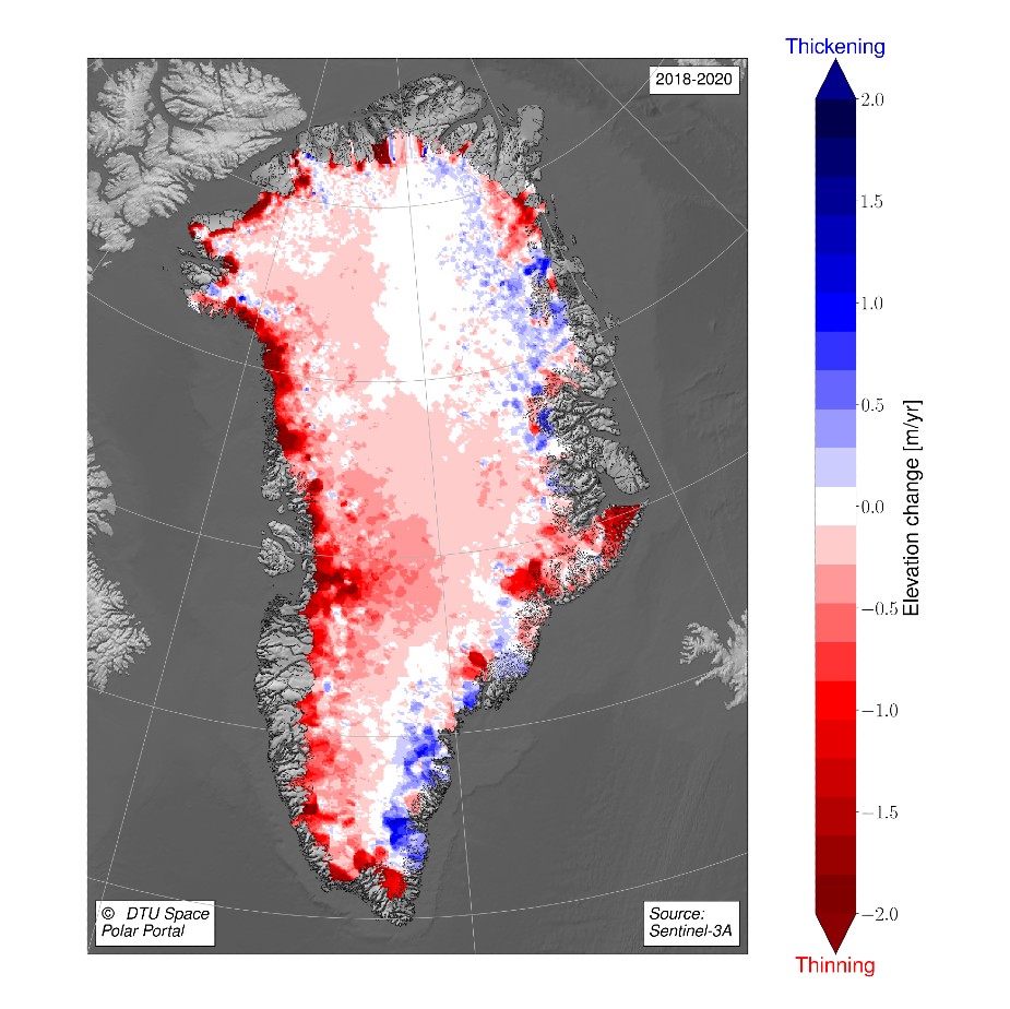
For example we have measured ice mass changes in the Arctic which directly contribute to the sea level rise observed in the last decades.
We are analyzing and validating satellite data of the ice sheets and sea ice in the polar regions, and other ice-covered parts of the Earth. DTU Space researchers have many years of experience in this field.
Among other things the Cryosphere group has contributed to ESA's satellite mission CryoSat-2, which measures the topography of the ice sheets and the sea ice with great precision. DTU Space has contributed to the mission by collecting valuable validation data with airborne campaigns in Greenland, the Arctic Ocean and Antarctica. These measurements ensure that the satellite data are processed correctly, and that the satellite is measuring correctly.

Changes in the Greenland ice sheet measured by ESA's Sentinel satellites. The amount of ice becomes smaller in areas marked in red, while it grows in areas marked in blue. (Illustration DTU Space/polarportal.dk)